The Lancieux Bay was gradually gained by man over the sea (polder). Over the centuries, the construction of dykes (Dyke of the Monks, Dyke of La Roche or Beaussais Dyke) and irrigation canals have allowed the development of agriculture.
The landscape has been made up over time according to the needs of the local community, alternating between salt meadows, vegetable farming, bocage meadows, apple orchards, cereal farming or wet meadows.
With the Conservatoire du littoral as the new landlord, turning to new agricultural activities started. The objective of creating permanent meadows without inputs is to improve water quality and reduce economic stakes in an environmentally sensitive area.
The Lancieux Bay has kept a wild character with a great diversity of natural landscapes despite being inhabited and used by man.
Between the 13th and 16th centuries, the Benedictine monks of the Abbey of Saint-Jacut built a dyke, today called Dyke of the Monks. It allowed them to dry up the marsh for agricultural use. Later, the Dyke of La Roche (18th century) extended the polder to its current limits. The site of the Beaussais Marsh (Ploubalay polder), separated from the Lancieux polder by a stream, was dried up by the construction of another dyke in the early 19th century. These two contiguous polders form a coherent whole in Lancieux Bay.
The Dyke of the Monks is the oldest heritage element of the site and represents a valuable testimony to the development of the land-sea interface over the past centuries.
The Adapto project for the site:
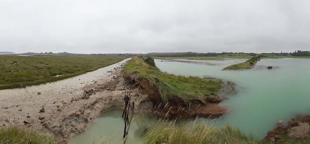
Global warming and sea level rise are causing changes on the coast. Today, during spring tides, the sea reaches the top of dykes and sometimes overflows them during storms.
Since 2015, reflection has been conducted on new forms of developments in order to anticipate the impacts of sea level rise. A strategy of a gradual dyke retreat will restore the earliest area that the sea used to cover.
To accept the maritime character of the bay is to transform the conception of its users and make them accept to give some space back to the sea and to create new areas for promenading.
Letting saltwater in the hinterland marshes while controlling it provides a new expansion area for the sea, absorbing some of its energy during storms, and reduces the cost of the construction and maintenance of protection works. The bay presents favourable conditions for adaptive coastal management. Several reconnection scenarios have therefore been evaluated for the Lancieux polder:
- The levelling of the dyke
- The creation of breaches
- The implementation of hydraulic management by lock
- Spontaneous submersions
In the town of Lancieux, this transition space allows to consider a protection system based on several measures:
- The rehabilitation of the old Dyke of the Monks for pedestrians;
- A new, limited-length dyke protecting goods and people between the Dyke of the Monks and urbanized areas;
- The infiltration of salt water into the area covered by the sea, creating a new marsh of salt meadows that dissipates marine energy.
The aim here is to balance different issues through a strategy of progressive managed realignment: heritage, environment and the use of natural areas.
Site chronicle
27th July 2011: Decision of the City Council of Lancieux to create a protection system based on several measures: to rely on the Dyke of the Monks and, if necessary, to build a third dyke to protect the camping site and the houses.
2015: Hazard study - Diagnosis of the state of the structure and recommendations for maintenance. Definition of the vulnerable area.
2016: Meetings with mayors and inter-communal elected officials: worries regarding the opinion of the inhabitants on the project. Request to highlight the benefits of the project for inhabitants and tourism. Awareness raising on the upcoming issue of climate change on which the Community of Communes will have to work in the context of the GEMAPI law (managing aquatic environments and flood prevention).
4th November 2016: Presentation of the results of the geomorphological and landscape university studies to elected officials of the Emerald Coast. Questioning about the funding of the project and the interest of undertaking a reconnection action rather than letting nature do its work. Request to have an estimate and a technical and legal feasibility study for each scenario.
15th November 2016: Day of exchanges between the Norman elected officials of the Val de Saire (LiCCo site) and the elected officials of the Lancieux Bay on the adaptation of coastal regions to climate change.
2017: "Ecosystem services of a Slikke-Schorre complex" + "Biogeomorphology and estimation of the Lancieux Bay salt marsh attenuation service" (EPHE study).
21st November 2016: Meetings with the City Council of Lancieux to issue a declaration of public utility to control land, a key element for the progress of the adapto project.
6th November 2017: Steering committee for the establishment of the GEMAPI.
11th July 2018: Site management committee of the Tertre Corlieu and Beaussais Marsh.
8th August 2018: Meeting with the Mayor of Lancieux regarding land purchase and hydraulic management of the Lancieux Marsh.
November 2018: Purchase of the parcel AH 238.
29th March 2019: Steering committee of the Lancieux Bay.