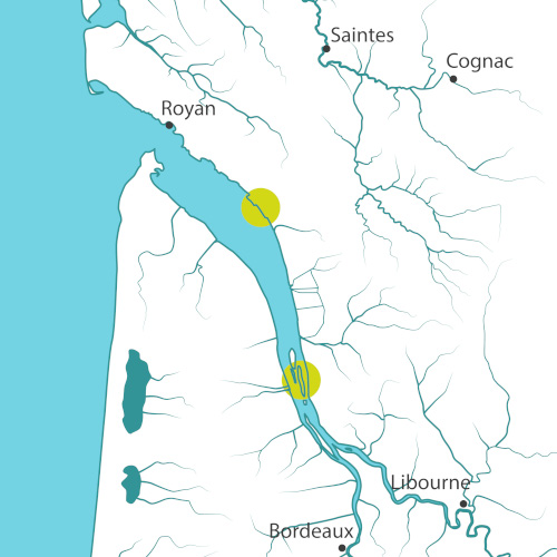
Covering a surface area of 635 square kilometres, the Gironde Estuary is the largest estuary in Western Europe. The alluvial deposits brought by the Garonne and the Dordogne Rivers contribute to the formation of silty soil in the Gironde estuary: every year between 1.5 and 3 million tons of suspended particles are deposited, forming banks that can evolve into islands. The polder of Mortagne-sur-Gironde and Île Nouvelle, formerly cereal farming land, were bought by the Conservatoire du littoral after storm Martin in 1999, when it was partly flooded by the sea. On this site, the Conservatoire has decided not to plug the breaches, to let the tide do its work, and to follow the evolution of these environments.
Mortagne-sur-Gironde Polders (17)
On the north bank of the Gironde Estuary, polders were created between 1960 and 1970 in the municipality of Mortagne-sur-Gironde in order to generate intensive agricultural production on previously unexploited estuarine salt meadows which were often covered by brackish water.
The 1999 storm Martin created breaches in the dyke of a polder located downstream of the port of Mortagne-sur-Gironde and the water invaded the area. To protect the houses, a new dyke was built further back towards the old shoreline. The Conservatoire du littoral purchased the parcels located in the former dyked area and the Regional Conservatory of Natural Spaces (CREN) of Poitou-Charentes has managed these lands since then.
On this site, the observed sedimentation rates are spectacular: in 10 years, the initial topographic level has been regained, and vegetation characteristic of the estuarine marsh has beengradually reconquering the area. In addition to the intrinsic qualities of these environments, reed beds play a buffer role by absorbing part of the energy of the incident swell and reducing its impact on the coastline.
L’Ile Nouvelle (33)
The Ile Nouvelle appears for the first time on the maps in 1825, first in the form of two islands (Bouchaud and Sans-Pain Islands) which will become a single entity after 1866.
The Ile Nouvelle had a rich agricultural period between the mid-19th century and the 1960s, including winegrowing, and its vineyardswere spared by the phylloxera epidemic. From the 1960s when cereal farming covered the majority of the land, the inhabitant gradually moved from the island.
After its purchase by the Conservatoire du Littoral in 1990, its management has been entrusted to the Department of Gironde since then. As the 1999 storm Martin made a breach into the bank of the island, water from the estuary has entered a part of the island since then. This phenomenon was concomitant with the regeneration program voted in 2000 by the Departmental Council: a natural wetland regains its ecological functioning and helps the development of a diverse fauna and flora. The 2010 storm Xynthia created a new breach in the northern part of the island; this area is regularly flooded by the tide and evolves rapidly.
The Ile Nouvelle was classified Sensitive Natural Area by the Department of Gironde: the southern part of the island (former Sans-Pain Island) is open to visitors. They can discover an example of regeneration of an estuarine space as well as the history of the archipelago.
The northern part of the island (former Bouchaud Island) is closed to the public to provide a large area of tranquillity for birds.
Project for the site
The Gironde Estuary is a valuable site for the adapto project because it benefits from comprehensive monitoring organized by its manager. The evolution of this area will serve as a reference for other sites which are not as advanced. The Gironde Estuary will feed the network of adapto sites facing similar challenges.
The presence of the two experimental sites will also make it possible to initiate reflections on the future of other polders in the Gironde Estuary which are in a similar situation, in order to carry out prospective studies with local stakeholders which will open up on several scenarios.
The adapto project will mainly implement extensive monitoring actions: study of the avifauna the piscifauna, the crustaceans, environmental mapping, sedimentation analysis and modelling, study of the social acceptance, assessment of the ecosystem services, analysis of the landscape evolution.
This dataset will allow to present to local stakeholders the ecosystem benefits of these natural areas.
Ile Nouvelle


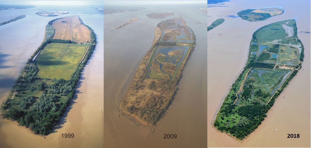
The Ile Nouvelle site is a very advanced example of adaptive coastal management completed in 2016. The beautiful development of the vegetation cover on two-thirds of the site, including reed beds, and of wildlife, including birds, is attested by a broad scientific monitoring since 2012.
The adapto project will focus on two actions:
- The implementation of the IRSTEA (National Research Institute of Science and Technology for Environment and Agriculture) Convention on ecosystem services (2018-2020) to provide an inventory of the impacts on the ecosystem after the estuarine reconnection.
- A thorough update of the habitat map by the end of the project.
This dataset will allow to present to local stakeholders the ecosystem benefits provided by these natural areas.
Site chronicle
Mortagne-sur-Gironde
September 2018: Renewal of the photo campaign for the Mortagne-sur-Gironde polders landscape observatory - CREN + aerial photo campaign.
Ile Nouvelle
30th May 2018: The adapto project is presented to the DREAL Aquitaine.
26th March 2018: Presentation of the adapto project to the management committee composed of the elected officials of the Department of Gironde, the manager (Department of Gironde) and the Conservatoire du littoral.
Summer 2018: 47 ha of Public Domain Fluvial assigned to the Conservatoire du Littoral by the Grand Maritime Port of Bordeaux.
Summer 2018: Screening of the film "What about tomorrow?” in a school in Pauillac. Organized by the Aquitaine Delegation of the Conservatoire du Littoral in partnership with the CPIE Médoc.
13th September 2018: Presentation of the adapto project to the Local Steering Committee which includes the site manager, its partners, local offices of the government and ministries, scientists and users.
November 2018: Signature of a partnership agreement with IRSTEA. Establishment of a research and development program to evaluate estuarine reconnection services on the northern part of the Ile Nouvelle through the study of the trophic network of aquatic communities, and an approach of associated ecosystem services.
2019
17th January 2019: Meeting of the Site management committee associating the Conservatoire du littoral/the Department Council of Gironde and the Department elected officials in attendance.
7th February 2019: Conference in Sadirac (33), introduction of the adapto project by the Aquitaine Delegation on the adaptive coastal management actions in the pilot sites in Aquitaine (Leyre Delta - Ile Nouvelle). Conference organized by the Terre et Océan. 40 people.